-
Archives
- November 2021
- June 2021
- March 2021
- December 2020
- October 2019
- September 2019
- March 2019
- July 2018
- April 2018
- October 2017
- June 2017
- May 2017
- February 2017
- January 2017
- October 2016
- September 2016
- April 2016
- March 2016
- January 2016
- December 2015
- November 2015
- July 2015
- June 2015
- November 2014
- October 2014
- September 2014
- August 2014
- July 2014
- June 2014
- April 2014
- February 2014
- January 2014
- December 2013
- November 2013
- October 2013
- August 2013
- July 2013
- June 2013
- May 2013
- April 2013
- March 2013
- February 2013
- January 2013
- December 2012
- November 2012
- October 2012
-
Meta
Tag Archives: drone
Seaport – Leaves of Glass
The recent ribbon-cutting for Mass Mutual at the Boston Seaport is one marker of the progress in this district. Mass Mutual was an original partner with Fallon Corp on the build-out which began in 2005. The district is all about … Continue reading
Posted in Uncategorized
Tagged above, aerial photo, architecture, boston, development, drone, glass, harbor, reflection, seaport, waterfront
Comments Off on Seaport – Leaves of Glass
Raffles Boston penthouse rendering
The Raffles Hotel project in Boston has begun its marketing campaign. Recent articles in Forbes and Boston.com show several renderings of the tower, located on Stuart Street, between Clarendon and Dartmouth. This image shows the penthouse terrace, with a view … Continue reading
Posted in Uncategorized
Tagged above, aerial, aerial photo, architecture, Binyan, boston, Copley Square, development, drone, panorama, Raffles, Raffles Boston, rendering, sunset
Comments Off on Raffles Boston penthouse rendering
Harvard SEAS Science and Engineering
The Paulson Center for Science, Engineering and Applied Science (SEAS) at Harvard University anchors the new Allston campus, just west of the Stadium and the Business School. Architect Stefan Behnisch has designed a wonderful new temple to Science, with a … Continue reading
Posted in Uncategorized
Tagged above, aerial, aerial photo, architecture, behnisch, boston, drone, harvard, Harvard SEC, landscape architecture, LEED, SEAS, Stimson, sunset, university
Comments Off on Harvard SEAS Science and Engineering
Chesterfield, MA
A perfect little village at a crossroads, Chesterfield sits on a hilltop in western Massachusetts. It has the essentials: a church, a library, a post office, a store, town offices, and a few Federal style houses. This aerial view is … Continue reading
Posted in Uncategorized
Tagged aerial, autumn, Chesterfield. landscape, church, crossroad, drone, hill town, maple, Pioneer Valley, village
Comments Off on Chesterfield, MA
Lenox panorama aerial
3-part panorama looking north from the Church on the Hill, Lenox, MA. Drone altitude is 400 ft.
Posted in Uncategorized
Tagged above, aerial, aerial photo, berkshire, church, congregational, drone, historic, Lenox, New England, village
Comments Off on Lenox panorama aerial
Fort Point panorama with LAANC
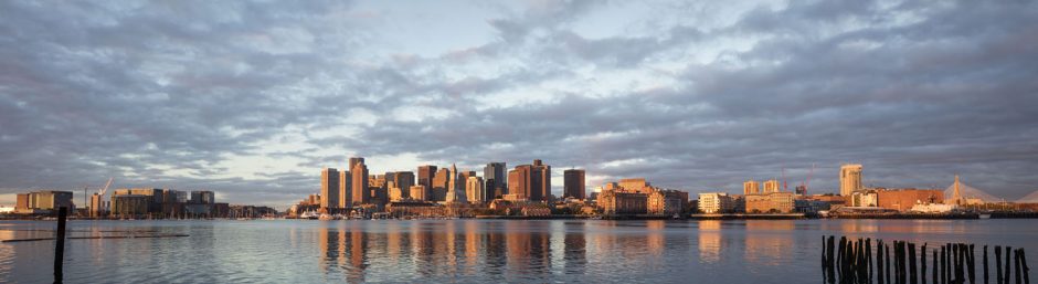
The FAA has introduced LAANC to facilitate drone authorizations in controlled airspace. Boston was activated in late 2018. This image was made with the new system. The panorama is made by merging 3 exposures: left, center, right.
Posted in Uncategorized
Tagged above Boston, aerial, boston, Boston skyline, drone, evening, Fort Point Channel, LAANC, panorama, skyline
Comments Off on Fort Point panorama with LAANC
Boston aerial sunrise clouds
On left, just before the sun clears the skyline buildings. On right, a few minutes later, as a scrim of clouds moves in from the west. The sun must be blocked to reduce its intensity. In this case, it is … Continue reading
Posted in Uncategorized
Tagged above, aerial, aerial photo, boston, Charles River, drone, inspire 2, skyline, sunrise
Comments Off on Boston aerial sunrise clouds
Drone evening Providence highway
Rush hour on Rt 95, as seen by the I2 drone flying over Federal Hill warehouses. This project was conceived for time-lapse, but some still frames are amazing on their own.
Posted in Uncategorized
Tagged above, aerial, aerial photo, architecture, blue hour, drone, drone aerial, inspire 2, magic hour, movement, pattern, providence, Providence Place, Rt. 95, skyline, sunset, traffic, transit, UAV, winter
Comments Off on Drone evening Providence highway
Drone photo of the week: Falmouth
Dinghies on the floating dock, West Falmouth harbor. Drone UAV image, from about 50 ft up. Inspire 2 aircraft, with X5s camera.
UAV – Drone photo of the week – construction
The UAV point of view allows low altitude work with surprising compositions. This construction site image was made from about 75 feet up.
Posted in Uncategorized
Tagged above, aerial, aerial photo, altitude, architecture, construction, development, drone, inspire 2, roofing, UAV
Comments Off on UAV – Drone photo of the week – construction